Tagged gis


Startups on a Mission to Expand the Use of Geospatial Insights, Raising the Bar for the Market's CAGR
The growth of the global geospatial solutions market has been recently driven by the substantial penetration of AI-based geographic information systems; however, it still limits the use of that data to end users with a tech background. But there's a way to change that.
Read Press Release


LandMentor - Neighborhood Design Technology & Education to Increase Living Standards, Reduce Costs, & Environmental Impact - Now Free
LandMentor is a market-proven solution in innovative design, surveying, architecture & engineering methods with technology to solve growth problems.
Read Press Release


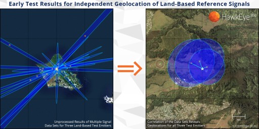
HawkEye 360 Awards Contract to Build Next-Generation Satellite Constellation to Achieve Rapid Revisit for Global Spectrum Awareness
Expanded constellation will geolocate more signals, increase revisit rate, reduce latency, and boost on-orbit capacity to meet growing customer demand
Read Press Release
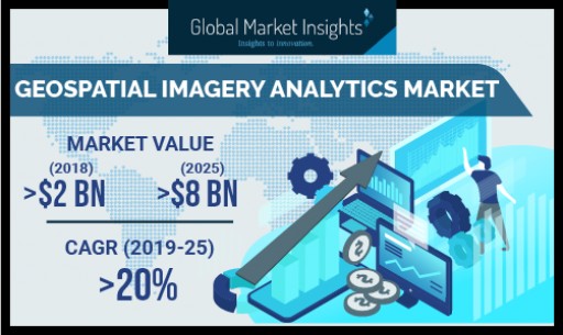
Geospatial Imagery Analytics Market to Cross USD 8 Bn by 2025: Global Market Insights, Inc.
Asia Pacific geospatial imagery analytics market will register 25% gains during the forecast period as various aerial imaging platforms, such as drones and surveillance cameras, are widely used in agriculture, construction, marine, and defense sector.
Read Press Release


International Association of Women Recognizes Judy Daniels, Ph.D., as a 2018-2019 Influencer
Dr. Judy Daniels, Founder, CTO and Principal Geospatial Soil Scientist for Terrestrial Systems, LLC, and Founder, CEO and Principal Geospatial Soil Scientist for Soil Sage, LLC, joins networking organization
Read Press Release
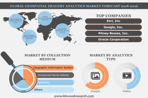
Global Geospatial Imagery Analytics Market to Grow at a CAGR of 30.90% by 2026
According to a new market research report launched by Inkwood Research, the Geospatial Imagery Analytics market is valued at $3000 million in 2017 and is estimated to generate revenue $37000 million by 2026, rising at a CAGR of 30.76% during the forecast period 2018-2026.
Read Press Release
CUEMA Elects Nobel Systems President Michael Samuel to Board of Directors
The California Utility Executive Management Association is the premier non-profit organization for utility professionals, their supporters and associates working in the great state of California.
Read Press Release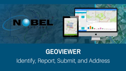


Ott Consulting Named Upper Mount Bethel Township Engineer
In January 2016, Ott Consulting Inc. (OCI) was appointed as the Township Engineer in Upper Mount Bethel Township, Northampton County, PA. The addition of Upper Mount Bethel Township brings our municipal client list to a total number of ten.
Read Press Release

Golden Software Releases Surfer® 13 With Lat/Long Graticule Lines and Viewshed Analysis
Golden Software releases Surfer 13, a contouring, gridding and 3D surface mapping program. New features include ability to perform viewshed analysis, display graticule lines, query features, and utilize more vector editing tools.
Read Press Release
Golden Software Releases MapViewer™ 8 with New Map Types and User-Interface Enhancements
Golden Software releases MapViewer 8, a mapping and spatial analysis software package. New features include an updated user interface, new map types, automatic link to WMS servers, and improved mapping options and querying.
Read Press ReleaseThe Undervalued Stock Report (Dot) Com Profiles Soul and Vibe Interactive Inc. (SOUL)
Soul and Vibe Interactive Inc., publishes games and games-related content for consoles, mobile devices and personal computers. Their product mix includes licensed-brands and internally generated, wholly owned, intellectual properties.
Read Press ReleaseCartegraph Introduces Flood Protection Technology for Local Governments
Inspired by its own hometown, Cartegraph creates the first technology solution designed especially for helping public sector agencies manage the assets and components of their flood protection systems.
Read Press Release